2026 Edition
Ultramarathon

Take the endurance challenge!
The .msg Maraton Apuseni Ultramarathon takes you through the most spectacular areas of the Apuseni Mountains, including the dramatic scenery of the Scărița-Belioara reserve, technical climbs such as the climb of Pietrele Mărunte and traditional hamlets. If the wild beauty of places such as Coșu Boului or Groapa Mare will enchant you, the alpine area of Muntelui Mare, which includes the passage past the weather station and the CAR Refuge – Romanian Alpine Club, will surprise you with memorable views of Buscat, Piatra Cântătoare and Creasta Stâncoasă!
It is indeed a route that requires preparation, energy and orientation, but also the joy of being up there, above it all, running at the rhythm of the mountain!
Discover the Ultramarathon route
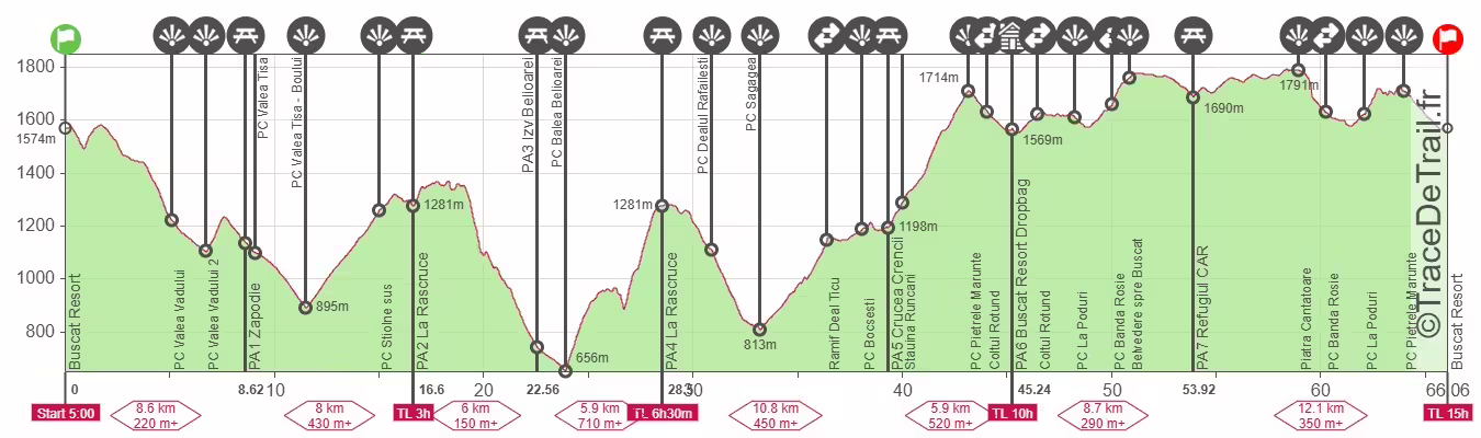
| Ultramarathon | Km total | Km difference | Elevation gain | Elevation gain between points |
|---|---|---|---|---|
| First Loop – the marathon via Scăriţa-Belioara Reserve | ||||
| Start | 0 | 0 | 0 | 0 |
| PC Valea Vadului | km5 | 86/-428 | 86/-428 | |
| PC2 Valea Vadului | km6,6 | 86/-554 | 0/-126 | |
| PA1 Zapodie | km8,4 | 8,4 from Start | 229/-642 | 143/-88 |
| PC Valea Tisa | km8,9 | |||
| PC Valea Tisa-Boului | km11,3 | 241/-898 | 12/-256 | |
| PC deasupra Stiolne | km14,7 | 591/-898 | 350/-0 | |
| PA2+4 La Rascruce | km 16,6 | 8,2 from PA1 | 665/-944 | 74/-46 |
| PA3 Izv. Belioarei | km22,7 | 6,1 from PA2 | 799/-1635 | 134/-691 |
| PC Valea Belioarei | km24 | 799/-1709 | 0/-74 | |
| PA2+4 La Rascruce | km28,2 | 5,5 from PA3 | 1500/-1782 | 701/-73 |
| PC Dealu Răfăileşti | km31 | 1539/-1996 | 39/-214 | |
| PC Săgagea | km33,4 | 1539/-2296 | 0/-300 | |
| PC Bocşeşti | km38,5 | |||
| PA5 Crucea Crencii | km38,9 | 10,7 from PA4 | 2018/-2392 | 479/-96 |
| PC Pietrele Mărunte | km42,6 | 2500/-2392 | 482/-0 | |
| PA6 Şesu Cald (dropbag) | km44,8 | 5,9km from PA5 | 2500/-2500 | 0/-108 |
| Second Loop – ultra across Muntele Mare / Big Mountain | ||||
| Colţ Rotund | km46,5 | |||
| PC La Poduri | km48,2 | |||
| PA7 Refugiul CAR | km54 | 9km from PA6 | 2774/-2656 | 274/-156 |
| PC La Poduri | km62 | |||
| PC Pietrele Mărunte | km64 | |||
| Finish Șesu Cald | km66,1 | 12,1km from PA7 | 3120/-3120 | 346/-464 |
Ultramarathon participation conditions
Compulsory equipment:
1. backpack/ waistband storage band
2. mobile telephone
3. water recipient
4. waterproof jacket
5. hat / headband
6. long pant/long tights
7. head lamp
8. survival blanket
9. track map / GPS device
Runners will be accepted at the ultra marathon race if they have already finished a number of long mountain running races until the start of msg Maraton Apuseni. Should a competitor be deemed unfit for the ultramathon race he or she will be directed towards the marathon race. Therefore, it is recommended you pay the registration only after you discuss in advance with the organizers.
Description
The ultramarathon has been redesigned to be easier than in previous years. It is similar in technical parameters to our ultramarathon in its launch year (2018), so we expect the winner to finish in under 8 hours.
The difference from that year and the similarity to previous years is that the ultramarathon loop is over Muntele Mare. As in 2018, it will start with the 45 km marathon loop (2,500 m elevation gain), followed by the 21.1 km ultramarathon loop (620 m elevation gain).
While the marathon loop takes you through the Scărița-Belioara reserve, the ultra-marathon loop offers views of Muntele Mare. You will even take a tour of the alpine area around the weather station near the peak of Muntele Mare – the third highest peak (1826 m) in the Apuseni Mountains. Why is it so impressive, not even reaching 2000 m? We can say simply: it is because it does not need to be bigger. Local competitions wanted to include the peak, but it was not possible. It is a whole plateau exposed to the elements, 10 km that you will want to cover quickly if the weather is bad. The refreshment point at the CAR Refuge is a good place to stop.
Even if you are already tired after completing the marathon route, it is worth taking a look around, as there are viewpoints not far from the route. We have marked the most significant points on the track.
First, you will pass the Belvedere Point towards Buscat, located just before entering the alpine area (km 50.5).
After passing the Refugiul CAR refreshment point and almost completing the entire alpine loop, about 100 m from the route, you will see some rocks on the right. They are called Piatra Cântătoare (Singing Rock) (km 59). Why? Because when the wind blows, even if it is not strong, you can hear whistling sounds. It is a point with good visibility over the Segăgia area, the reserve, i.e. the places you have passed through before.
The third point on the list is Creasta Stâncoasă, the rocks you will have to climb from PC La Poduri, thus reaching the juniper-covered peak of Pietrele Mărunte. The entire winding run along the path through the junipers offers spectacular views.
If you have time to come and check out the route or if you are passing by Muntele Mare, don’t forget this loop and also visit Tinovul (molhașuri) La Poduri, which starts at PC La Poduri, passes by two small lakes and is now mostly covered with wooden walkways.
The first part, the ‘marathon loop’
This year, we are keeping the same route as last year, starting with a descent on the blue ski slope and going around Muntele Boului, passing from Valea Tisa to Valea Boului. Why is it called that? The easiest way to find out is to ask someone who knows: those who have been there and can tell those who haven’t.
So, the climb up Pietrele Mărunte at the end remains, as does the circuit in the Scăriţa-Belioara reserve.
Also, as in previous editions, sections 1 and 4 of the Marathon coincide with the route of the Half Marathon.
The race starts in Şesu Cald using the blue ski slope for the start, after 200 m of level ground followed by a high-speed descent to enter an uphill trail also used for MTB.
This leads to the well-known descent to Valea Vadului.
After 5km, you reach the first checkpoint, PC Valea Vadului.
PC2 Valea Vadului is not far away, at km6.6. You will get there quickly; we estimate that you will all pass through within 20 minutes.
Turn right over the water and then follow a road that climbs diagonally left through the pasture to the top of Dealul Boinic. Then descend on the opposite side on a path that passes through the huts of Zăpodie/La Zăpozi.
Here, at Zăpodie, is PA1. It is a picturesque place suitable as a refreshment point, located at km 8.4.
Then turn slightly left to bypass the marshy area and cross the Tisei Valley. You will reach PC Valea Tisa.
From here comes the new section, surrounding Muntele Boului, no longer passing directly to the Ştiolne huts. Follow the Tisa stream downhill and at km 11.3, where it joins the stream with the same name, leave the Tisa and climb towards PC above Ştiolne, located at km 14.7.
Those at the Valea Tisa-Boului checkpoint will guide you. At the checkpoint above Ştiolne, the half-marathon runners turn right towards Ştiolne, heading back to the finish line, but we haven’t warmed up yet, so we continue climbing.
From the top of Muntele Româneasa, turn left and descend gently to a wide saddle where, at km 16.6, you will find PA-2/4 La Răscruce, which you will pass again later!
From here, continue uphill towards the boundary of the Scărița-Belioara Reserve. Cross the reserve (meadow, then sparse pine forest) to the edge of the cliff, above the deep valley called Groapa Mare. Turn left carefully onto the path that follows the edge of the cliff. Enter the forest on the left for a short while, then return to the sunny slope. You are now back on the edge of the Gropii Mari cliff, then re-enter the forest where you can see traces of a fire (a path through fallen and charred trees), descend for a while on the ridge, then turn sharply right onto a winding path. BE CAREFUL not to dislodge any rocks that could injure those further down! You will exit the forest in the La Cornu Pietrei clearing, where you turn right and climb about 20 m to the saddle.
From Șaua Cornu Pietrei, descend along the road through the beech forest, then climb gently along a path through the birch forest and come out at the beautiful Dealu Brădățel peak. You will descend with a superb view of the steep limestone cliff on your right, where you can see the large arch Coșu Boului/Coșu Belioarei and Groapa Mare, and in front of you, Dealu Bilii, which you will reach. At the edge of the forest, you will find a path that takes you to the right into the dry valley called Răstoaca and then to the left along it to PA-3 Izvorul Belioarei, located at km 22.7, halfway through the marathon route.
From here, descend 1 km on the valley road to PC Valea Belioara/Colțul lui Balmoș, then cross the stream and climb a local path through meadows, among old houses and barns, then diagonally to the right to the peak called Dealu Bilii. Follow it to the right, then descend to the right until you reach the edge of the forest. Here you will find the tourist trail marked with a red PR point, which you follow to the left uphill through the La Stânci area, using the ropes placed by the Salvamont members in the steeper areas. Pass through the forest and three clearings; in the third, called ‘La Măteoaie’, there is a spring where the thirstiest among you can quench their thirst, although after another 15-20 minutes through the forest, you will reach PA-2/4 La Răscruce again. You are at km 28.2.
Those who have not exceeded the time limit will continue on the path that ‘slaloms’ through juniper trees, then through the forest, to Fântâna Popii – a spring with a ‘ciurgău’ (a type of waterwheel). After exiting the forest at the top, descend a short distance through juniper trees, and markings will direct you to the right towards PC Dealu Răfăileștilor, then to the left until you reach Valea Mărginită. Keep left for 1 km; in previous years there was a PA here. In the village, at an intersection, you will find PC Săgagea, at km 33.4, from where you are directed to the hill with the two small churches, then right onto the narrow streets that lead you to Dealu Țicului, and enter the forest on the forest road. Follow it to the right for another 1.8 km until you reach PC Bocșești, not far from the new PA, where you are at km 38.5 and where the runners from the half marathon come from the right.
You will then cross three marshy springs and arrive at a few more huts and a sawmill: PA5 Crucea Crencii, km 38.9. There is a 4 km steep climb to Pietrele Mărunte, which can take up to an hour to reach the top.
Turn left uphill towards the Stăuina Runcanilor clearing, enter the forest on the left, and soon turn right again onto a forest path. You will come out into a mountain hollow full of junipers, through which the path leads you to PC Pietrele Mărunte, km 42.6. You have about 2 km to go to the drop bag point (Șesu Cald).
Descend gently to the right, pass a small wooden hut, and you will reach the ‘military road’ (Colţul Rotund). Turn right and descend gently to reach PA6 Șesu Cald, km 45, which is the start-finish point and drop bag point. Don’t forget that there is also a time limit here, 10 hours from the start!
Second part, ‘ultra loop’
The route starts with the forest road (military road) towards Muntele Mare. Please note that you are the only ones from all the races who follow the red line (BR) ahead.
One thing that must be said and known from the start, because an ultramarathon runner always thinks ahead about what to do and what to pay attention to, is that the ultra track contains loops. When it comes to sections that are covered twice, with different directions to follow, a regular GPS does not warn you in advance about the direction to take. So, after the start, you run towards Muntele Mare.
There is a small change from the classic climb in previous years, at approximately km 50 (5 km from Șesu Cald), you leave the forest road to the right among juniper trees. It is harder to climb, but not by much, and the route will take you straight to the Belvedere Point towards Buscat, the rocks we mentioned in the introduction. You will reach the alpine area and follow the BR markings that go around the military unit on its right to reach PA1 Refugiul CAR. After passing the military unit, the weather station is on the left. So, if you see a large illuminated ball on your left and your mobile GPS seems to have gone haywire, it’s not a UFO. However, if the ball is on your right, then either it is a UFO or you have taken a wrong turn. For the second option, the rule is to return to the last reflective marker you saw.
In total, it is 9 km from Șesu Cald to PA7 Refugiul CAR, mostly uphill. At the refuge, which is quite well hidden by vegetation, being further down the valley, get ready for 6 km of running on a plateau full of grassy paths that can confuse you. Around the weather ball, follow the reflective markers. When your GPS warns you, you may be as much as 40 m off the road. You have 13 km to go to the finish.
From the CAR Refuge, the route first abandons the BR to reach the CR. At that change of direction (km 57), the return journey practically begins. Follow the CR to the left and you will pass not far from Piatra Cântătoare. Soon the descent begins on the forest road (military road) towards Șesu Cald. Follow it persistently until you reach PC La Poduri (km 62).
Here our volunteers will direct you to Creasta Stâncoasă, towards the peak of Pietrele Mărunte. You will enjoy a very beautiful route through juniper trees. Don’t worry, it’s not difficult; it is also part of a MTB competition in September.
Once you reach PC Pietrele Mărunte (km 64), the last two kilometres are clear and easy, as you have already covered them on the first loop, the marathon.
You have completed or revisited one of the most beautiful mountain running trails, which has taken you through places where you felt like ‘wanderers through the past’ and where you ran ‘to the rhythm of the mountains’!
We look forward to seeing you every year with the love we have for all people who love and practice outdoor activities and who respect the cleanliness and tranquillity of the mountains!